Gliwice
Gliwice. Lot from the square
Distance
72 km SE, 25 km NE, 103 km NE, 41 km NE, 47 km S, 38 km SE, 39 km NV, 11 km S, 111 km SE, 53 km N, 23 km SE, 43 km SE, 73 km NV, 54 km SE, 25 km NE, 52 km SE, 47 km SV, 22 km E, 28 km SV, 39 km E, 40 km E, 40 km NV, 21 km E, 23 km NE, 32 km SE, 10 km E, 35 km SPopulation
204.800 (2002)
Location and history
Gliwice is a historic town located in the western part of the Upper Silesian industrial area. Through the city, the river Kłodnica runs, which together with the Gliwice canal connects the city with the great river Odra to the west. The densely built industrial and urban area, called Katowice Area , is thus immediately east of Gliwice. To the west of the town extends a large forest area, Lasy Raciborskie.
Gliwice is known for a dynamic development in both the business and cultural fields. Gliwice plays a significant role as a scientific and educational center in Upper Silesia. Here you will find schools at all educational levels as well as several scientific institutes. A large part of the academically trained teachers are employed by the Silesian Polytechnic Institute. Young people, who make up over half of the city's population, have access to a wide range of educational offerings. Higher education people make up a relatively high percentage of the city's population.
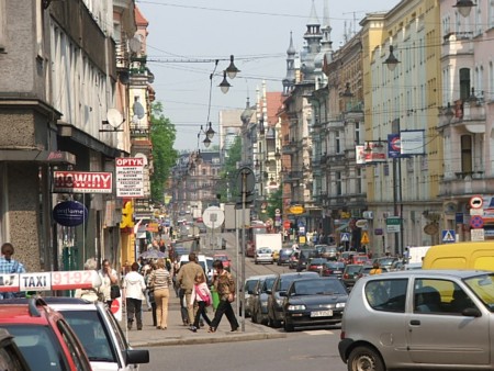
From Gliwice’s busy center: ul. Zwycięstwa, seen to the northeast
Gliwice existed as a city as early as the 13th century. The town is first mentioned in the sources in 1276; at this time Gliwice was within Poland's borders. From 1312 the city was the capital of a principality. Throughout the Middle Ages, the Gliwice area was subject to the Czech crown. In 1431, the city was surrounded by walls that formed another line of defense, supplementing the hundred-year-old ramparts and moat. In 1742 Gliwice became part of Prussia and was given the German name Gleiwitz. The development of a larger city took off at the end of the 18th century. with the building of a large metal mill. In 1845 the railway line from Wrocław to Gliwice was opened. In 1895, electric trams with features on all four axles – like the first in Europe – began to run in Gliwice. colliery “Gliwice” began operations in 1912. The city of Gliwice was granted to Germany in 1921 as a result of a previous referendum – despite a Polish victory in the municipal elections 2 years earlier. The construction of the modern Gliwice channel was completed in 1938. On 31 August 1939, Hitler supporters were behind an attack on the German radio station in Gliwice; this so-called Gliwice provocation was used as the occasion for the German attack that started the Second World War. On 24 January 1945, Gliwice became Polish again. Also in 1945, the city became the seat of the Silesian Polytechnic Institute. On June 27, 1990 – after the change of system – the first free elections to the City Council were held. In October 1998, the car factory Opel Polska was inaugurated in Gliwice, which represented the largest foreign investment in Poland.
Gliwice has a direct connection west to Germany via the major highway / highway A4 (E40) which goes south around Strzelce Opolskie, Opole, Wrocław, Legnica and on to the border. east, the E40 motorway passes through the Katowice area and on to Kraków.
Tourist attractions
Gliwice differs significantly from the other cities in Upper Silesia, i.a. the city is characterized by lush greenery in the form of old parks and large residential neighborhoods.
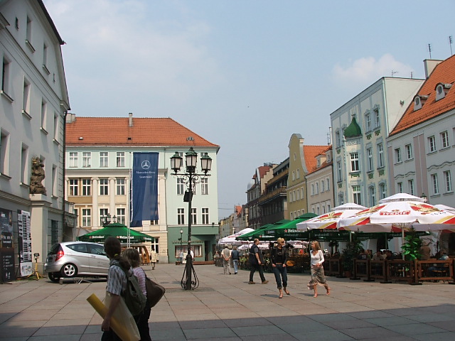
Old Town Square.
The square is surrounded by 18th and 19th century townhouses, with archways. In the middle of the square stands the town hall.
City Hall.
The town hall was built as a seat for the city authorities at the end of the 13th century. However, the current building dates from the 15th century. In the basement are brick residues that originate from the former town hall. The building was renovated in 1980’s.
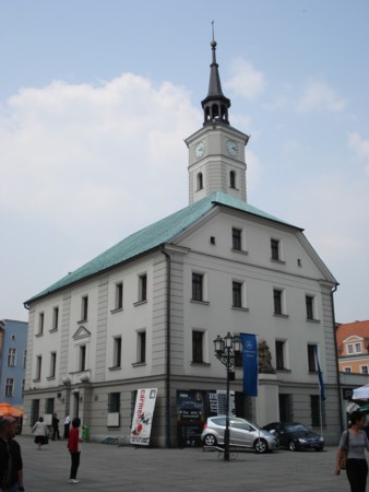
City Hall in the square
The city wall.
Remains of the medieval city wall, which was 1125 m long, were still visible, ca. 9 m high and 1-1½ m wide. The wall was equipped with 29 fortress towers and 2 gates (Brama Bytomska and Brama Raciborska).
In aerial photos of Gliwice, the old town is clearly seen as an elliptical area, bounded by the houses that were / located along the original city wall.
The castle (Zamek Piastowski).
The castle in Gliwice was built in the Middle Ages in connection with the construction of the other defenses around the city. The building worked, among other things. like the city’s arsenal. In the 17th and 19th centuries. the castle was rebuilt several times. The building is now a museum.
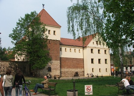
The former castle in Gliwice, now a museum
Willa Caro / City Museum.
The building, erected in the second half of the 19th century. in neo-Renaissance style as a private residence for a prominent industrialist, now houses the City Museum, created in 1905 by the Upper Silesian Society of Museum Friends in Gliwice.
St. Peter and Paul's Cathedral .
The church, built in 1886-1900, is one of the most beautiful examples of neo-Gothic church art in Silesia. In the church is an organ from the company Rieger, the best of its kind in Upper Silesia. The cathedral is therefore the venue for many organ concerts throughout the year.
All Churches of the Saints (Kościół Wszystkich Świętych) .
The associated church parish was founded in the middle of the 13th century, but you do not know what the first church looked like. The current three-story building was built in the 15th century; sleek octagonal columns separate the ships. Underneath the church, remains of Gothic walls and arched portals, which testify to the building's medieval origins, have been uncovered.
All Saints Church
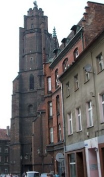
The radio station.
Gliwice has his own “Eiffel Tower”, namely the radio station tower. Attached to the radio station is the memory of a tragic incident in 1939 (see above under history). The tower is a world-class engineering work. The building material is larch wood; the joists are assembled with brass screws; no single iron stitch is used. The height of the tower is 110 m; The foundation is 20 × 20 m. After the war and until 1956, the tower was used as a broadcast mast for Radio Katowice. Later it is has been used as an antenna mast for mobile telephony.
Neptune Fountain
Near the town hall, in the western part of the square, is a characteristic fountain with a sculpture of the sea god Neptune sitting on a dolphin. The fountain was inaugurated in 1794 to mark and commemorate that the city had been connected to the sea via canal construction, namely via the river Odra to the Baltic Sea. The artist was Johannes Nitsche, a sculptor from Opava of his time.
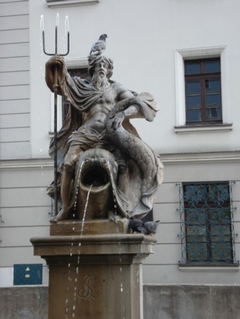
Neptune sculpture on the square in the old town
Surrounding Area
To the east are Zabrze, Bytom and the many other cities in Katowice Area .
forests:
A few kilometers west of the city extends the large forest area, Lasy Raciborskie, bounded to the northwest by Kędzierzyn-Koźle, to the southwest by Racibórz, to the southeast by Rybnik and to the northeast by Gliwice.
Lakes:
Immediately northwest of the city are 3 artificial lakes (water reservoirs): Dzierżno Duże, Dzierżno Małe and Pławniowice.
wooden architecture:
In the surrounding area you can see several examples of wooden built Silesian churches.
Accommodation and Restaurants
Gliwice. Miejski Serwis Internetowy – in Polish, English, German, French, Russian. – Here also practical information for tourists
Other Internet sites and sources
Gliwice. Miejski Serwis Internetowy – in Polish, English, German, French, Russian.
Translated into English by Google Translate. Spangshus.dk accept no liability for any errors or omissions in translation.
Map
Rating
Search
Most used tags
churches (205) Castles (86) Monasteries (79) Town walls (74) Lakes (71) Town halls (67) Rivers (65) Castles1 (62) Mansions (55) Museums (51) Regional museums (38) Town gates (36) Abbey churches (35) Castle ruins (30) Cathedrals (26) Forests (25) Health resorts (24) Water sports (23) Mounds (23) National parks (22)Click for all tags
Denne side er også tilgængelig på dansk. This page and contents is (c) Copyright 2018- www.spangshus.dk. Based on Inviator software by ISCA Software