Gryfino

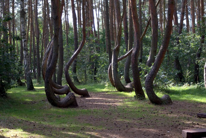
Krzywy Las / The Leaning Forest at Gryfino. – Picture of Kalasancjusz from Pixabay
Distance
Population
21.700 (2011)
Location and history
Gryfino is located in northwestern Poland, south of the county capital of Szczecin. The town is located on the river Odra (Oder), ie. at the German border. Two bridges lead road no. 120 over respectively. the main river East Odra and the river arm West Odra. In Germany, it becomes road # 113.
Gryfino was granted commercial property rights in 1254, issued by the Pomeranian Prince Barnim I. In 1271, the city was granted the right to create artisan guilds and merchant guilds according to designs from Szczecin. From the 14th century Gryfino was a member of the Hanseatic League. From 1640-1679 the city was occupied by the Swedes. Before leaving the city, they destroyed part of the city wall and bridges. 2nd half of the 19th century. was a rising time for the city; new suburbs arose and there was a rail link to Szczecin. Around 1930 several new factories were built. At the end of World War II, in 1945, Gryfino was captured by the Soviet army and subsequently the city was incorporated into the Republic of Poland.
Tourist attractions
Selected attractions:
Virgin Mary's Church of the Nativity
Built in the early Gothic style, the parish church is a three-tiered building with a transverse ship, a square choir, and a west-facing tower with a square floor plan. The building of the church began in 1278.
Bymuren
In 1284 the prince gave permission for the construction of a defense force around the city. In the first period this consisted of a soil wall, later a field stone wall was built with a height of about 6 meters (today at most 4 meters) and a perimeter of 1.9 km. To this day, several fragments of this wall are preserved.
Brama Bańska
The heavy gate tower, Brama Bańska, was an important element of the city's defense system from 1300. The foundation is 2.5 meters below ground level. Today, modern streets and roads have to be passed around the gate, but in the Middle Ages, the doorway was obviously used for passing through, although it was already too narrow at that time.
Surrounding Area
The town is located on the Odra (Oder) border river, which runs in a south-north direction. South of Gryfino, the river has divided into two. Between the main river and the left river arm (West Odra) lies the Lower Odra Valley Landscape Park. From Gryfino and south, West Odra forms a border with Germany.
A short distance to the northeast extends the Szczecin Landscape Park. To the east of Gryfino lies Lake Wełtyń. In particular, the west bank of the lake is a significant recreational area.
Krzywy Las / The Leaning Forest located 4 km from the center of Gryfino and there are 200 – 300 crooked pines. The cause of this abnormality is not yet known. (See photo at the top of the page)
Accommodation
Booking.com
Gryfino – with practical information for tourists
Other Internet sites and sources
Translated into English by Google Translate. Spangshus.dk accept no liability for any errors or omissions in translation.
Map

Rating
Search
Most used tags
churches (205) Castles (86) Monasteries (79) Town walls (74) Lakes (71) Town halls (67) Rivers (65) Castles1 (62) Mansions (55) Museums (51) Regional museums (38) Town gates (36) Abbey churches (35) Castle ruins (30) Cathedrals (26) Forests (25) Health resorts (24) Water sports (23) Mounds (23) National parks (22)Click for all tags
Denne side er også tilgængelig på dansk. This page and contents is (c) Copyright 2018- www.spangshus.dk. Based on Inviator software by ISCA Software