Kętrzyn
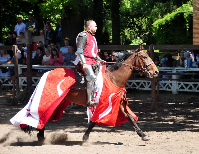
From a knight tournament held in Kętrzyn. – Photo by: robert.zakrzewski on Flickr
Distance:
Population
28.256 (2012)
Location and history
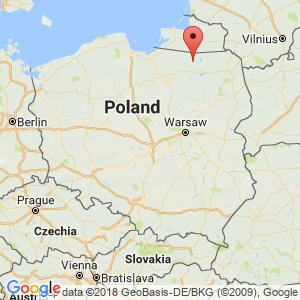
Kętrzyn is located in northeastern Poland, in the Mazury region, 32 km south of the border with the Russian Kaliningrad district.
The area where Kętrzyn now lies was inhabited by the Bartians, a Prussian (Baltic) tribe in the early Middle Ages. They were exterminated, displaced or Germanized by the Crusaders who in the 13th century. penetrated and gradually ruled the Prussian territory, formally for the purpose of Christianizing and pacifying the pagan inhabitants. The Order erected a castle at present Kętrzyn. In the middle of the 14th century. a defensive wall was erected around the settlement.
The area then became part of German East Prussia. The word Prussia is otherwise derived from the word “prusere” (German: Prussia), the Baltic tribes that populated the area before the Germans and Poles.
Kętrzyn grew up in the shadow of the castle and in 1357 was granted market town rights. A bombing in 1942 and fighting in 1945 led to the destruction of approx. 40% of the city.
After World War II, in 1946, the area became Polish and incorporated into the newly created Olsztyn county. The Polish name of the city was first Rastembork, which soon after, in 1946, was changed to Kętrzyn.
Tourist attractions
Crusader fortress
The Crusaders erected at present Kętrzyn a smaller wooden built fortress, which in 1329 is referred to in the documents as Rastenburg. From the mid-1300s, the Order erected a stone-built castle in the southeast corner of the city. It was – and still is today – a three-story building complex, which to the west was closed with a barrier wall through which a gate. The most important wing was the northern one. The other wings were economy buildings. In the courtyard a well was dug for the castle's water supply.
The castle was partially destroyed during World War II, but reconstructed in 1960’the old drawings. The buildings now house a museum.
Saint Jerzy Church
The church was erected in the middle of the 13th century at the site of the first Crusader fortress. It is the best-preserved defense church in Mazury. The pulpit must be highlighted from the 16th century. and the organ from the 18th century.
Great School
Near St. Jerzy's Church stands another church building, St. John's Church. It was built in the middle of the 16th century. by rebuilding a cemetery chapel from the end of the 15th century. It was called “the Polish Church“because the worship here was in Polish. From 1546 there was also a school in the building. Latin was taught, but the compulsory subjects also included German and Polish. However, teaching in Polish ceased around 1830. One of the students of the school was the later historian Wojciech Kętrzyński (1838-1918), who fought against the Germanization of the Polish population, and which the city is now named.
Surrounding Area
The lakes:
To the east there are only a few kilometers to a complex of large lakes, of which Mamry and Dargin are the largest. Closer to the city, also to the east, are two smaller lakes: Mój and Siercze.
Wolf's Lair
In the Gierłoż forest 8 km east of Kętrzyn, Hitler built a headquarters in 1941 for the purpose of directing the army forces that fought against the Soviet forces. The headquarters was called Wolfsschanze (in Polish: Wilczy Szaniec, in Danish: The Wolf Chance). It was a very extensive complex of many buildings, most of them concrete, while some were brick buildings. There were several bunkers, including Hitler's own bunks, which were specially secured against air strikes. The building complex was fenced, fortified and guarded to an extreme degree. The watch crew was obviously numerous. In total, over 2,000 people were employed at headquarters. On July 20, 1944, Claus von Stauffenberg executed an unsuccessful attack on Hitler in a conference room here. In January 1945, as the Soviet army approached, the buildings were blown up. The place is now a museum that can be visited by tourists.
Accommodation
Eating Out:
Other Internet sites and sources
Kętrzyn The city's official site.
Translated into English by Google Translate. Spangshus.dk accept no liability for any errors or omissions in translation.
Map
Rating
Search
Most used tags
churches (205) Castles (86) Monasteries (79) Town walls (74) Lakes (71) Town halls (67) Rivers (65) Castles1 (62) Mansions (55) Museums (51) Regional museums (38) Town gates (36) Abbey churches (35) Castle ruins (30) Cathedrals (26) Forests (25) Health resorts (24) Mounds (23) Water sports (23) National parks (22)Click for all tags
Denne side er også tilgængelig på dansk. This page and contents is (c) Copyright 2018- www.spangshus.dk. Based on Inviator software by ISCA Software