Międzyrzecz
Castle of Międzyrzecz
Distance
Population
18.947 (2003)
Location and history
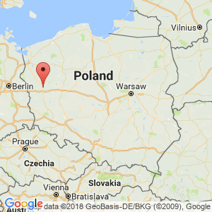
Międzyrzecz is located on the eastern outskirts of the Lubusz lake landscape (23 km north of Świebodzin), surrounded by forests and lakes. The town is on the River Obra, a tributary to Warta.
Międzyrzecz is one of the oldest fortified cities in Polish territory. Through the city, the roads went from Gniezno to Magdeburg, from Szczecin to Wrocław and on to Kraków. The oldest fortification on the site is mentioned in Thietmar’s Chronicle during the year 1005. Międzyrzecz gained market town rights before 1248. The development of the city is furthered by its defense-favored location at the junction of two rivers: Obra and Paklica. To the south and east was the city shielded by a defensive force, behind which ran a moat; this one encircled a rather steep high on which the actual fortress was situated. Międzyrzecz played an important role as a border fortress on the Polish western border.
Next to the fortress, the urban development developed, which over time became a garment industrial center. The beautifully constructed city became the seat of a star ballot; star cheese (district manager) of Międzyrzecz was, among others, Chancellor Jan Zamoyski.
The planning and building of the medieval city was linked to the road leading from Poznań to the castle of Międzyrzecz. In the old town, to this day, it has largely retained the characteristic, fan-shaped street course for the medieval town: three major streets that run along the bridge leading to the castle. Such a course was also dictated by the topographic conditions with the two riverine arms enclosing the urban area in a triangle. The square was located on the main street of the city, which leads in the direction of Poznań. In the middle of the square stood the town hall, equipped with a tower. Close to the town hall stood a number of booths.
Historical sources show that Międzyrzecz in the middle of the 15th century. was the largest city at Wielkopolska’s western border. The city's prosperity lasted until the end of the 16th century. The following two centuries were a period of downtime or decline. The city was plagued several times by epidemics and fires.
In the year 1793, in connection with Poland's 2nd division, Międzyrzecz, along with the whole of Wielkopolska, was occupied by Prussia.
From 1945, the city and the region came again within the borders of Poland. After the war and until 1948, 23,629 people from the former Polish territories in the east were transferred to this area. Around 1957, the reconstruction of most of the city had been completed and new living quarters were built.
By the last municipal reform in 1999, Międzyrzecz district (powiat) was restored within the framework of the Lubusz region (Województwo Lubuskie).
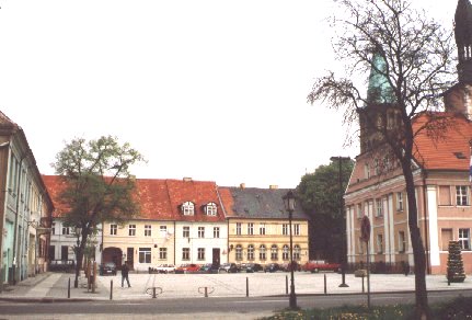
The square in Międzyrzecz with the town hall on the right in the picture
Tourist attractions
Museum of Międzyrzecz , ul. Podzamcze 1. – Including: the castle, the residence of the star cheese, the gatehouse, etc.
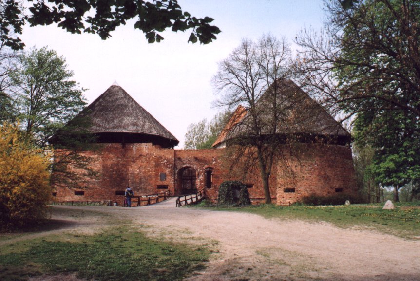
Borgen . – The first castle was built of wood. A walled castle was erected in Kazimierz the Great's reign. The exact time is unknown, but construction is thought to have begun before 1340 and completed after 1350. The walls – except the northern section – were erected on the old earth walls. There was entrance to the castle from the east side. Housing sections were found in the western and southern part of the courtyard. In 1520 the castle was taken and set on fire by German forces. In connection with the rebuilding after the destruction, the building received a renaissance mark. A modernization of the plant followed in 1564. Two cylindrical fortress towers were then added. The well-preserved southern fortress tower is built of brick. The inner diameter of the tower is 10-11 m and the wall thickness is 3.5 m. The castle was the residence of the star cheese. During the 30-year war in the 17th century. the castle was destroyed and it took a long time before anyone took care of the buildings again. In 1954-58, thorough investigations of the archaeological and architectural nature were carried out on site.
The residence of the star cheese from the beginning of the 17th century.
Porthuset was recreated in 1985 based on the original half-timbered building from the 18th century, which was destroyed in 1945.
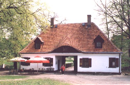
The gatehouse near the castle
City Hall was erected using a privilege of King Stefan Batory in 1581. Remodeled by 1813. The building is in a classicist style; the bell tower is crowned by a neo-gothic tower hat. Attached to the town hall is the story of an attack on Napoleon I., who spent the night in the city in 1806.
Saint Wojciech’s Church is a late 1834 classic building.
The Church of John the Baptist is from the end of the 15th century, a Gothic, brick building with pillars. The church hall is divided into 3 ships.
The Jewish Synagogue dates from 1824.
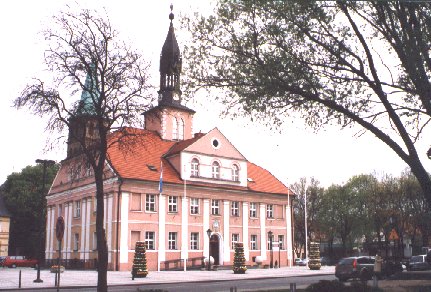
Międzyrzecz. City Hall
Surrounding Area
seascape .
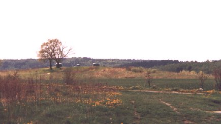
The largest lake in the immediate area is Jezioro Głębokie (112 ha; in Danish: Dybsø), located 4 km north of the city. The lake offers excellent opportunities for a holiday by the water, not least for divers. Particularly picturesque is Lake Kurskie (77 ha), which together with the lakes Długie and Chycińskie create a belt of water northwest of Międzyrzecz. 5 km east of the town you will find Lake Bobowickie, which together with two smaller lakes is located in a beautiful forest complex, rich in plants and animals. Another beautiful lake is Jezioro Bukowieckie, 5 km south of town. The wide range of lakes along the Obra River, east and southeast of Międzyrzecz, is a pure paradise for anglers.
Forest land.
Międzyrzecz municipality has one of the largest forest coverage percentages in the country. Between 49 and 50 percent of the area is forest, especially pine forest.
kayaking .
The river Obra can be navigated by kayak.
The Fortified Międzyrzecz Region (Międzyrzecki Rejon Umocniony, abbreviated as: MRU ).
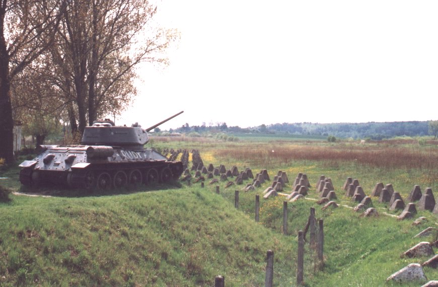
The old German fortification line in the area extends about 80 km from north to south, from the Warta region of Gorzów Wielkopolski to the Brody locality on the river Odra. The most interesting section is definitely the Fortified Międzyrzecz Region, located south of Międzyrzecz in the direction of bwiebodzin. Dozens of fortifications are linked here by mile-long, underground corridors.
After World War I, Germany, in its military planning, assumed that a future war would take place in the west, against France, but at the same time, it was believed that Poland, as an ally with France, would make military advances in the direction of Berlin. plan of giant fortifications. Several hundred mighty plants, interconnected with underground passages, were planned and equipped with heavy machine guns, flame throwers, mortars and even heavy guns. The underground passages should be up to 100 km long. There were also huge magazines and living quarters for the crew underground. The various plants were to be connected to tracks like those used in the coal mines. Soldiers, equipment and ammunition were transported through this network. The fortifications should be heated and have water supply, and above all, they should be resistant to external attacks. In these facilities, thousands of soldiers were to survive and fight the enemy for several months.
The first works were carried out in 1925. Roads were built and terrain studies were carried out. The complete project was completed in 1935. The most extensive work consisted in the excavation of the underground passages. On elevations in the terrain, the elements of the fortification that were above ground level were built. By the end of 1937, the MRU was already partially ready for battle. The last building tape began in 1944, under the impression of the immediate threat of attacks from the east.
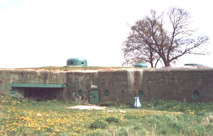
Along the entire fortification line, dozens of iron concrete bunkers were created. Ca. Twenty-one of them were connected to a system of underground corridors at a depth of 30-50 m. The main corridor ran in the north-south direction, and from this emerged side corridors; from these, concrete stairs went up to the individual bunkers, which were covered with thick steel domes above the ground, and where there were machine rooms etc.
However, the colossal fortification did not play a significant role during World War II. On January 30, 1945, it was conquered by the Red Army. At the site of the breakthrough MRU now stands a memorial obelisk, erected by fragments of a ruptured bunker.
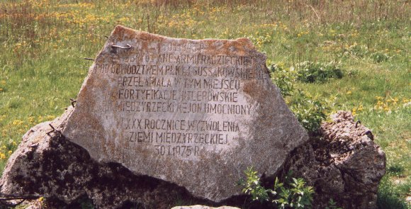
Memorial stones erected at the site where the fortifications line was broken in January 1945 by the Soviet army.
After World War II, the piles and the underground plant were abandoned and almost forgotten and eventually fell into disrepair. When humans left the underground spaces, they were taken over by bats. Section North and Section South of MRU can be visited individually. The central section can be visited in the area of Bats Reserve I and II; Visits – for a fee – can be made between April and October, but only with the driver. However, plants that lie above the ground can be visited individually.
bats Reserve “Nietoperek” and “Nietoperek II” .
Ca. 12 km south of Międzyrzecz, in the Pniewo locality near the village of Kaława (in the area of the fortified Międzyrzecz region (see above)) is one of the largest wintering sites for bats in Europe. Each year, approx. 30,000 bats, divided into 12 species. Many of the animals that occur here belong to rare and endangered species. Studies have shown that some bats fly up to 260 km to overwinter in this place, e.g. from Mecklenburg and Brandenburg in Germany.
In 1980, part of the fortified Międzyrzecz region and in 1999 the whole was recognized as a nature reserve. The underground parts of the fort can be visited, but only certain sections and only with driver.
Accommodation
Gmina Międzyrzecz The official site of the municipality – with practical information for touristsOther Internet sites and sources
Gmina Międzyrzecz The official site of the municipality
The fortified Międzyrzecz region:
Miedzyrzecz Underground Fortifications
Translated into English by Google Translate. Spangshus.dk accept no liability for any errors or omissions in translation.
Map
Rating
Search
Most used tags
churches (205) Castles (86) Monasteries (79) Town walls (74) Lakes (71) Town halls (67) Rivers (65) Castles1 (62) Mansions (55) Museums (51) Regional museums (38) Town gates (36) Abbey churches (35) Castle ruins (30) Cathedrals (26) Forests (25) Health resorts (24) Water sports (23) Mounds (23) National parks (22)Click for all tags
Denne side er også tilgængelig på dansk. This page and contents is (c) Copyright 2018- www.spangshus.dk. Based on Inviator software by ISCA Software