Jelenia Góra
Jelenia Góra. From Town Hall Square
Distance
Population
85.541 (2008)
Location and history
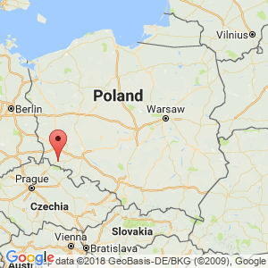
Jelenia Góra is located in the southwest corner of Poland, in the Lower Silesian region. The town lies in a valley formed by the rivers Bóbr and Kamienna, closely surrounded by mountains to the west, north and east; to the south there are only a few kilometers to the Karkonosze Mountains along the Czech border.
A fortified city with a Slavic population was founded here (by the rivers Bóbr and Kamienna’s confluence) at the beginning of the 12th century; the initiative for the foundation is attributed to the tradition of Bolesław Krzywousty. The merchant site that developed in this place was granted merchant town rights at some point before 1288. The town became known early on for its production and export of flax canvas, but a metal industry also developed, based on raw materials from nearby Kowary. From 1392 the city came under Czech rule and from 1527 under Austrian domination. The result of the bloody Thirty Years War and later the Silesian Wars became the city's incorporation into Prussia and later Germany. After World War II, the city became Polish again. From 1975-1999 Jelenia Góra was the capital of the county of the same name. The city is today an economic, administrative (district capital) and tourist center in this part of the county.
The village name means in Danish: Hjortebjerget; the city's name in German times was also: Hirschberg.
Among Jelenia Góra’s foreign friendship towns are the Danish city of Randers.

From Town Hall Square
Tourist attractions
City Hall
The classicist town hall building emerged in 1747, designed by CGHedemann. On the south wall is a blackboard with a Latin inscription that reads in translation: “The city was built by Bolesław Krzywousty in the year 1108”.
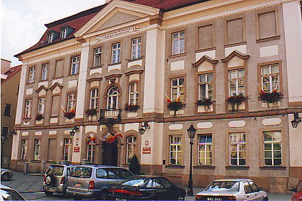
City Hall facade
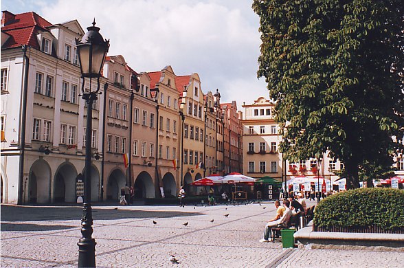
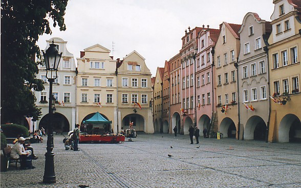
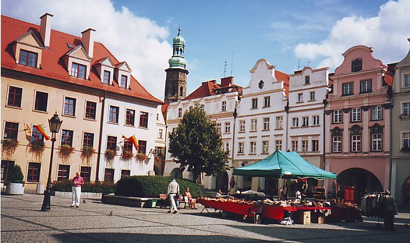
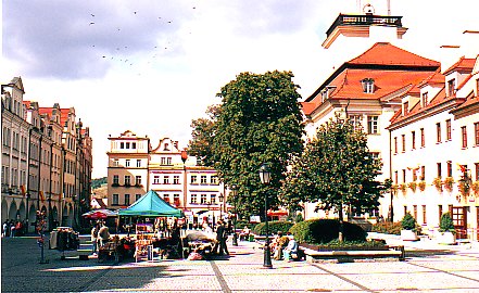
The Square (Rynek) / Town Hall Square (Plac Ratuszowy)
The square was the central point of the medieval town where the main connecting roads met. The square has a rectangular shape and is surrounded by restored Baroque-style houses with the only fully preserved row of archways in Silesia.
From Town Hall Square
Remains of the city wall
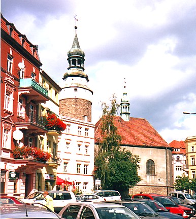
Remains of the fortification of the city from the 14th century. is preserved at ul.Jelenia, near St. Erasmus and Pancratius Church.
Castle Gate Tower (Wieża Bramy Zamkowej)
This is the only preserved element of the Borg Gate, which in its time guarded the entrance to the city. The tower was erected in 1584 instead of a previous tower that had collapsed. In the upper part of the building there are slips.
Castle Fortress (Baszta Grodzka)
This tower is a former defense tower, an element of the defensive wall that surrounded the city. The tower was built in the 15th century; in the 18th century. it was converted into a residential building. Today it houses the Tourist Office.
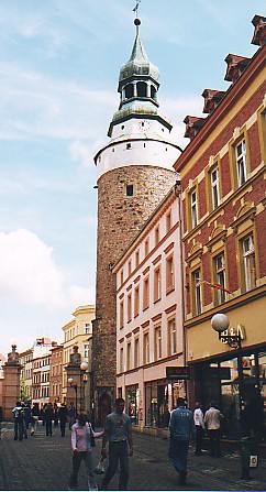
Wojanów Gate Tower (Wieża Bramy Wojanowskiej)
After the original tower collapsed in 1480, the building preserved to this day was erected. The tower, which once guarded the entrance to the city from Wojanów, has an altitude of 38.4 m. It is equipped with slots and observation openings. A twisted staircase leads to the top, and one of the ledges probably formed an exit to the city wall.
Wojanów port tower
St. Anne's Chapel (Chaplain Aw.Anny)
In 1514, an extension to the Wojanów Gate Tower was made in the form of a brick tower / chapel. After a fire, a defense church was built instead, built according to drawings by Kaspar Jentsch in 1709-15. On the church wall facing ul.Bankowa you can still see a number of slots. Here you also notice a walled cross (zone cross); in the Middle Ages, a man of iniquity, e.g. a murderer, being charged with raising such a cross as part of the atonement of his crime.
Wojanów Gate Tower and St. Anna's Chapel
St. Erasmus and Church of Pancratius (Kościół św. Św. Erazma in Pankracego)
The church dedicated to Jelenia Góra’s patron saint, is built 1304-46, under the first Henryk Jaworski’s control. It is a Gothic building erected by bricks and sandstones. Interiors are in Baroque and Renaissance style.

Saint Erasmus and Pancratius Church tower
Jelenia Góra Theater
The theater building was built in 1903-1904 by drawings by the local architect Alfred Dähmel. It is a three-story Art Nouveau building that was modern at the time. The large theater hall seats 550 people.
The Palace in Czarne (Dwor w Czarnem)
Archaeological studies have shown that before 1559 a castle existed in the village of Czarne (today a district in Jelenia Góra). This castle probably dates from the 12th century. In 1559, a member of the Schaffgotsch family, Kasper II, erected a mansion on the foundations of the former castle; the building was surrounded by a moat. After several fires, the mansion gained a renaissance character with a remodel following drawings by architect Ernest Nimptsch. After the Second World War, the mansion was taken over by a PGR – a state farm, which caused a major progressive destruction of the building. In 1980’The mansion was bought by the Polish Ecological Club, which has since sacrificed large sums to renovate the building.
From Town Hall Square. In the background the tower of Saint Erasmus and Pancratius Church
Surrounding Area
The spa town of Cieplice (about 9 km southwest of the center of Jelenia Gora)
Cieplice is today part of the city of Jelenia Góra.
Cieplice attractions include:
Schaffgotsch Mansion (Pałac Schaffgotschów)
The current mansion is built in place of the family's former home, which was destroyed by fire. The construction lasted from 1784-1788 and was led by architect Jan Rudolf from Opole. The affinity of this classicist building to the genus Schaffgotsch, one of the most prominent Silesian families, bears two coats of arms over the entrance. Today, the building is the seat of the Wrocław Polytechnic Educational Institute's Didactic Center.
Spas (Zdrojowy Park)
The spa park links with the Schaffgotsch mansion in Cieplice. The French-style castle park was first mentioned in 1748. In 1838, the park was basically rebuilt, now in English style.
The Long House (Dlugi Dom)
This building was part of the Cistercian Order's monastic complex. It was the Cistercians who originally owned Cieplice. The house later became a hotel for caterers. Today it is the seat of the spa's management.
Spas (Dom Zdrojowy)
The current health center is directly opposite “The Long House”, it was built in 1929-31 as a replacement for earlier spa buildings.
Sobieszów (about 12 km southwest of the center of Jelenia Gora)
The castles of Chojnik (Zamek Chojnik)
The castle is located on the Chojnik ridge over the Sobieszów locality. It was built in the 14th century. of the first Bolko II of the Piast genus (idwidnica-Jawor line). The castle was part of the fortification of the Principality's border. Among the later owners was the genus Schaffgotsch, who expanded the Chojnik castle in the Renaissance style. After a major fire in 1675, the castle is largely a ruin, currently available to the public.
Accommodation
Booking.com
Jelenia Góra (The city's official site in Polish, English, German and Czech) – with links to download brochures for tourists
The spa town of Cieplice – with practical information for tourists
From Town Hall Square
Other Internet sites and sources
Jelenia Góra (The official site of the city in Polish, English, German and Czech)
Translated into English by Google Translate. Spangshus.dk accept no liability for any errors or omissions in translation.
Map
Rating
Search
Most used tags
churches (205) Castles (86) Monasteries (79) Town walls (74) Lakes (71) Town halls (67) Rivers (65) Castles1 (62) Mansions (55) Museums (51) Regional museums (38) Town gates (36) Abbey churches (35) Castle ruins (30) Cathedrals (26) Forests (25) Health resorts (24) Water sports (23) Mounds (23) National parks (22)Click for all tags
Denne side er også tilgængelig på dansk. This page and contents is (c) Copyright 2018- www.spangshus.dk. Based on Inviator software by ISCA Software