Paczków
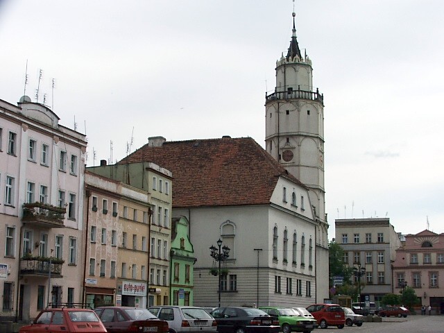
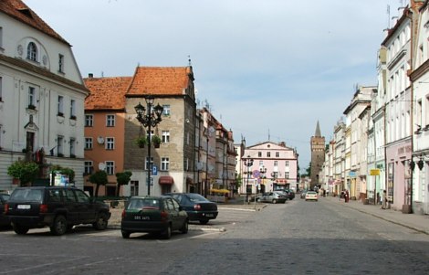
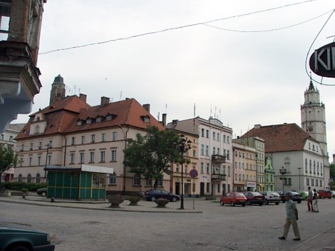
The square in Paczków with the town hall as seen from the north
Distance
Population
8.300 (2007)
Location and history
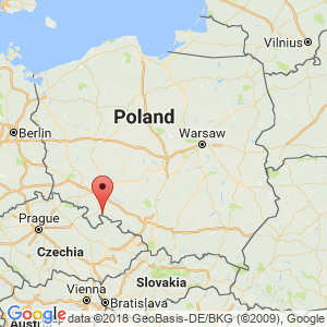
The town of Paczków is located in the south of Silesia, on the river Nysa Kłodzka, west of Lake Otmuchów and a few kilometers north of the border with the Czech Republic. Administratively, Paczków belongs to Opole County.
Around the city there are city walls and fortifications that are among the very best preserved examples in Poland of urban defense architecture.
Paczków was a Slavic settlement that developed into a major city. The town is mentioned in chronicles as early as the 11th century. In 1241, Paczków was attacked by Tatars who invaded Silesia. In 1254, the town was granted commercial property rights by Bishop Tomasz I of Wrocław; these rights included several privileges, including the right to brew beer. The earliest documents refer to the most common craftsmanship in the city, such as the butcher's, baker's and cobbler's crafts. Probably from the beginning the city was fortified to some extent. The first fortifications were probably of wood and soil. In the middle of the 14th century. the city was surrounded by double defensive walls and a Catholic church was erected – a three-tiered half-church. Even earlier, a castle mentioned in the year 1301 had been erected; The castle probably stood on Góra Zamkowa (Castle Hill), but is believed to have been destroyed at the beginning of the 15th century. The center of the old town was a square called the Market (Targ). The church stood in the southeastern part of the city. In the double wall around the city there were three gates: Dolna (Lower Gate), Górna (Upper Gate) and Łazienna (Bath Gate).
During the first centuries, the city had to survive several of the typical plagues of the Middle Ages, such as hunger, flood and plague. In 1428, Paczków was captured by the Hussites, causing great destruction in the city. In the second half of the 15th year. Paczków was given a number of episcopal privileges to improve the city's economy. Artisan gifts arose – or resurfaced – among other things. extensive weavers, butchers, bakers, bundlers and blacksmiths. In 1483 a salt market also arose.
At the end of the 15th and the beginning of the 16th century. people worked to strengthen the fortifications of the city. The city had the right to hold four markets a year; these also contributed to the development of the city. At the beginning of the 17th century. the city had 2800 inhabitants. But the cholera epidemic in the early 1600s and later the 1930s war was disastrous for the city and its inhabitants. A new economic development started only in the first half of the 18th century, this time unfortunately interrupted by the Austro-Prussian war. As a result of this war, Paczków came under Prussian rule (1741).
Only in the 19th century. there was a renewed improvement in conditions in Paczków, including building or remodeling of schools, hospital, town hall and building a new bridge; At the same time, the industry, which mainly utilized local raw materials for the production of various wood products, was developed, as well as a match factory.
Paczków also maintained in the 20th century. its position as a small border town with a solid business base. World War II did not cause any special damage to the building mass in Paczków, but the great relocation to the city after the war, where the city gained many new inhabitants who had no emotional relationship with Paczków, unfortunately meant that many historic buildings were neglected and in some cases destroyed. . In 1956, a plan for reconstruction of Paczków was adopted – on the basis of historical studies; renovation of the old buildings began in 1974.
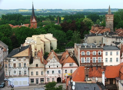
The northeast side of the square as seen from the town hall tower. In the background, the Wrocław Gate Tower (th.) And the former Evangelical Church tower (TV)
Tourist attractions
Paczków is called the Polish Carcassonne (French medieval town) because its old defenses are among the best preserved in Poland and because many centuries ago the city emerged as a fortified city. To this day, the city is almost completely surrounded by a defensive wall with brick towers and gates. The towers are from the 14th century; today, 19 of 24 towers have been preserved. Also connected to the wall are the gate towers: the Wrocław Gate Tower and the Kłodzko, Ząbkowice and Nysa Gate Towers. The parish church, the Church of John the Evangelist, also carries defensive building features. Also worth noting are certain civic houses, the town hall, the executioner's house and the gas museum. A tourist attraction is also the river sailing from Bardo and north of Paczków to Lake Otmuchów.
St. John the Evangelist Church (Kościół Parafialny pw św. Jana Ewangelisty), ul. Kościelna
The construction of the Church of John the Evangelist was begun before 1360 and the church was consecrated in 1389. In recent centuries the church was rebuilt several times. Around the middle of the 15th century. the Maltitz Chapel was erected at the choir, and in 1701 a chapel on the north side was added. It is a defense church, built of bricks as well as a small amount of natural stone.
Above the west portal are two coats of arms belonging respectively. Wrocław Diocese of Przecław of Pogorzela and the Nysa area (Diocese's weapon). At the choir is to the north the great tower and the sacristy, to the south the chapel of Mary from ca. 1447. The chapel contains an altar built in sandstone and donated by the Maltitz family in 1588. mentioned Kutner’s neo-Gothic altar and Buhl’s pulpit from 1889, adorned with figures of the 4 evangelists. Mention should also be made of the diverse Gothic vaults. Inside the church is the well-known well, called “Tatarbrønden“that was useful if the city were to be besieged.
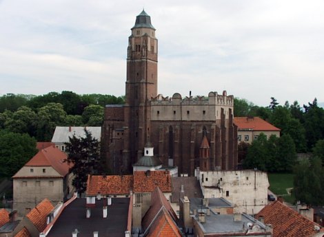
Saint John the Evangelist Church seen from the Town Hall tower
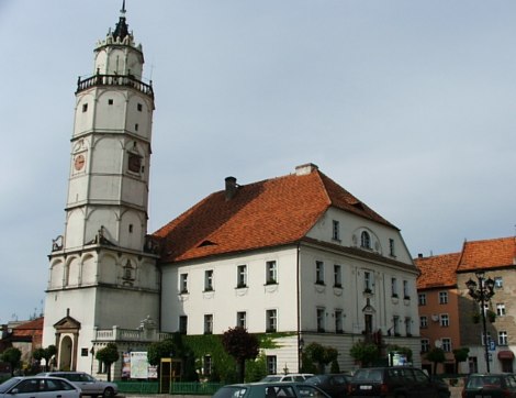
City Hall (Ratusz), Rynek 1
The town hall was built in 1550 at the behest of Bishop Baltazar Promnitz, but of the original building, however, only the 45-meter high tower from 1552. The lower part of the tower is square, while at the top it turns into an octagon. It is one of the best preserved Renaissance towers in Silesia. The City Council Hall is beautifully designed. Above the main entrance of the town hall are the city's weapons and Bishop Promnitz’s weapons from 1550.
The town hall and the town hall tower on the square
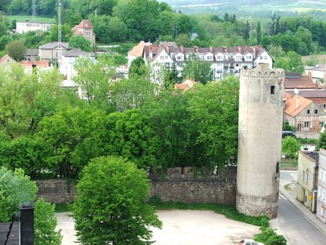
The city wall with brick towers
The city wall, as we know it today, already existed in the middle of the 14th century. The building material used exclusively natural stone, which originated from a quarry at the village of Chałupki northwest of the city; Subsequently, the wall was reinforced with brick towers, totaling 24. The total length of the wall was approx. 1200 meters. The individual wall sections (between the towers) were approx. 9 meters high and equipped with masonry roofs. In the second half of the 15th year. the invention of firearms made it necessary to reinforce the fortification, which is why an extra, outer ring wall was erected – outside the moat. This new wall was lower, and only the foundations are preserved to this day; it was demolished in the early 19th century. In 1847 the moat was filled. In 1891-99 a renovation of the fort was completed and a reconstruction of broken parts of the wall and brick towers. – The old town is still today almost surrounded by the wall, which is regularly provided with the half-round brick towers, open towards the city and with cone-shaped helmets. The fortification also includes the four gate towers.
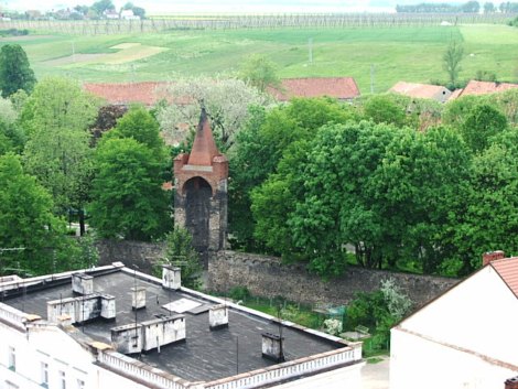
Part of the city wall with one of the brick towers, seen from the town hall tower
Townhouses on the square
A prosperity period in the 16th year. gave rise to the bourgeoisie replacing their former wooden houses with foundation-walled dwellings. Some townhouses in the square have retained features from the Renaissance, despite later remodels in the 18th and 19th centuries.
Wroclaw port tower (Wieża Bramna Wrocławska), ul. Wrocławska
The Wrocław Gate was formerly called Brama Dolna and defended access to the city from the northeast. It was built in the middle of the 14th century, partly demolished in 1429 and rebuilt in 1462. Like the other gate towers, this is built of natural stone, supplemented with bricks. Characteristic of this tower is the pointed helmet that was reconstructed in 1919-24.
The tower is a viewing tower with public access during the summer season from May to September.
The southeast side of the square seen to the northeast with ulica Wrocławska and the Wrocław gate tower in the background
Kłodzko port tower (Wieża Bramna Kłodzka), ul. Narutowicza
This gate and the gate tower were formerly called Brama Górna. The tower was built in the 15th century. with an extension in 1595. The lower part of the tower is square; the upper part is cylindrical and provided with slots. This gate guarded access to the city from the Czech side. The tower was renovated in 1900-01.
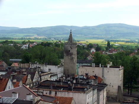
View from the Town Hall tower over the southern part of the old town; in the middle of the picture is the Kłodzko Gate Tower
Ząbkowice port tower (Wieża Bramna Ząbkowicka), ul. Sikorskiego
The Ząbkowice Gate Tower was formerly called Wieża Bramna Łazienna as it stood near the city's former bathhouse. The cylinder-shaped tower was erected in the middle of the 14th century. This gate guarded access to the city from the northwest.
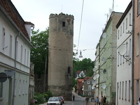
Ząbkowice Gate Tower at Sikorski Street, northwest of the square
The executioner's house (Dom Kata), ul. Wojska Polskiego,
dating from the 18th century, is a two-storey half-timbered building that is currently the seat of the Company of Paczków’s Friends.
Gas Museum (Muzeum Gazownictwa), ul. Pocztowa 6
It presents equipment for the production of city gas, as well as all kinds of household appliances, for which gas was used, such as stoves, ovens, fireplaces, etc. and examples of old gas meters.
Surrounding Area
Kamienica (about 5 km southwest of Paczków)
The village, called Kamienica Nyska, is located on the Czech border and is the largest village in Paczków municipality; the population is approx. 1200th
Here you should see the Church of Saint Jerzy with baroque and rococo style equipment from the 18th century. (altars, pictures, sculptures, pulpit, organ and baptismal font). The church is surrounded by a stone wall with two gates – one from the 16th century, the other from the 18th century.
Lisie Kąty (about 6 km south of Paczków)
The village, located on the Czech border, was founded in the 13th century. In the center of the village is a Renaissance manor house with a residential tower from approx. 1600, which in the 19th century. was rebuilt in neo-Gothic style.
Stary Paczków (approx. 2 km east of Paczków) This village was originally called Paczków, but was named Stary Paczków (Old Paczków) as the trading center of the same name developed a few kilometers to the west to the current market town of Paczków.
Fishing:
Fishing in the river Nysa Kłodzka and in Lake Otmuchów.
bathing:
There is a beach at the village of ibcibórz (Lake Otmuchów).
Biking:
There are several descriptions of bicycle routes in the area, such as a Polish-Czech bicycle route that goes from Lądek-Zdrój via Javorník (in the Czech Republic) to Paczków and Otmuchów. The Czech Republic shoots west of Paczków a land tongue to the north, separating the Nysa region (with Paczków – to the east) and the Kłodzko region (with Lądek-Zdrój – to the west). On this route you can experience the mountains of Góry Złote and the descent from the mountains (in the Czech Republic) overlooking the lowlands where Paczków and Otmuchów are located.
Accommodation
Booking.com
Paczków – here also practical information for tourists
Eating Out:
Paczków – here also practical information for tourists
The building in the middle of the square as seen from the north; in the background TV tower of St. John the Evangelist Church
Other Internet sites and sources
Paczków – Polskie Carcassonne (The official site of the city – in Polish, English, German and Russian)
Printed literature:
Dąbrowski, Kazimierz: Paczków – szkice z dziejów miasta. Opole, 1996. 118 p.
The Ząbkowice Gate Tower on Sikorski Street, seen from the Town Hall Tower
Translated into English by Google Translate. Spangshus.dk accept no liability for any errors or omissions in translation.
Map
Rating
Search
Most used tags
churches (205) Castles (86) Monasteries (79) Town walls (74) Lakes (71) Town halls (67) Rivers (65) Castles1 (62) Mansions (55) Museums (51) Regional museums (38) Town gates (36) Abbey churches (35) Castle ruins (30) Cathedrals (26) Forests (25) Health resorts (24) Water sports (23) Mounds (23) National parks (22)Click for all tags
Denne side er også tilgængelig på dansk. This page and contents is (c) Copyright 2018- www.spangshus.dk. Based on Inviator software by ISCA Software